For this hike you need to park your vehicle on Highway 11 roughly 55km south of the Nordegg turnoff by an unnamed creek. For this hike you need to park your vehicle on Highway 11 roughly 55km south of the Nordegg turnoff by an unnamed creek. Named after the British Army Training Unit Suffield (BATUS) this area was a rock-climbing area for the unit prior to one soldier losing his life here, now quite popular in the winter with ice climbers.
Distance: 0.98 km
Elevation: 194m
For this hike you need to park at the Pinto Lake Recreation Trail staging area off of Highway 11, 48 km south of the Nordegg turnoff. Starting at the Pinto Lake Trailhead, this short hike is under 3.5km return with an elevation of only 36m as seen on the profile below, shortly after the trailhead within a short distance follows Cline River upstream as it makes its way towards the falls, although being Bear Aware is important on all hikes, any hikes within this area, do watch out for signs of bear activity, both multiple grizzlies and black bears are known to be in this area, as there are usually a few closures each year due to bear activity.
Distance: 3.43km
Elevation Gain: 36m
Park on Highway 11 at the Coral Creek Trail Parking Area 47 km south of the Nordegg turnoff. This is a part of the Cline and Coral Canyon Loop and I also use it sometimes when hiking the coral creek trail on the return leg.
Distance: 1.85km (one way)
Elevation Gain: 102m
Park on Highway 11 at the Coral Creek Trail Parking Area 47 km south of the Nordegg turnoff. At about 15km one way this hike follows Coral Creek and at just past the 4km mark of this hike is a waterfall known as Triple Punchbowl Falls, while most turn around here, you can continue from here.
Distance: 14.89km
Elevation Gain: 394m
As this is accessed from the Coral Creek Trail park on Highway 11 at the Coral Creek Trail Parking Area 47 km south of the Nordegg turnoff. Starting from west side of the Cline and Coral Canyon loop on the Cline Creek trail, this 5.5km return hike has an elevation of 651m and should not be done during the winter without proper courses such as ast1 and experience in avalanche terrain. From the top the reward for doing this climb is a breathtaking view of Abraham Lake, the North Saskatchewan River Valley as well as Cline River. To reach this hike is about 3km in, so in a return make sure to add 6.2 km to the 5.5km distance of the hike, giving you a total length of about 11.2 – 13.3km depending on which route you chose to take to access it.
Distance: 5.49km
Elevation Gain: 651m
For this adventure park your vehicle off Highway 11 at the David Thompson Resort roughly 46km south of the Nordegg turnoff. A simple easy walk up to and with a great view of Abraham Lake. Good for the whole family. Little Indian Falls can also be accessed from here, see The David Thompson Highway Hiking Guide for more info. A short hike under 4km you can do from your campsite in the evening after supper.
Distance: 2.73km
Elevation Gain: 70m
Accessed from the camping area at Pinto Lake. See Pinto Lake Trail for more info on how to access this area.
Distance: 3.71km
Elevation Gain: 26m
For this hike you need to park at the Pinto Lake Recreation Trail staging area off of Highway 11 48 km south of the Nordegg turnoff. Recommended for experienced hikers, this roughly 35km long hike sees an elevation gain of a steep upward 761m with the majority of height gained over 3km, this is at minimum a 3 day hike as you might want to spend some time along the way. Best hiked in late summer or early fall.
Distance: 36.18km
Elevation Gain: 761m
For this hike you need to park at the Pinto Lake Recreation Trail staging area off of Highway 11 48 km south of the Nordegg turnoff. On the map to your right I have this trail starting OFF THE Lake of The Falls Trail, as I chose it as a side trip from that hike. This whole hike is roughly 34 km return and features a lake. I recommend doing it in two days minimum so you can enjoy the hike and surrounding views. If planning on doing this hike, like others in the Cline River Area, make sure to carry bear spray, I recommend 2 cans if you are a solo hiker like myself, along with a type of inReach device, I personally use a Garmin Gpsmap66i, better to be safe than sorry.
Distance: 36.4km (return)
Elevation Gain: 624m
The turnoff for this trail is located on Highway 11 around 42km south of the Nordegg turnoff at the waste transfer site. A minimum of 2 days is needed to complete this hike, I recommend at least 3 so you can enjoy the scenery and not be exhausted before you return to work or after you return home. With an elevation gain of roughly 1080m (don’t worry about the profile below, those two dips you see are an error in the trail created by the GPX file, my friend lent me. All the other info in the profile is correct and as you can see from the profile there is avalanche terrain located near Littlehorn pass, so be aware if doing this hike in the early spring as this could still be a factor from winter.
Distance: 33.38km
Elevation Gain: 1080m
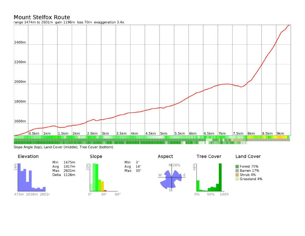
The turnoff for this trail is located on Highway 11 around 42km south of the Nordegg turnoff at the waste transfer site. This hike starts at the end of the Whitegoat Creek Trail after the turnoff on your left which leads to Whitegoat Falls (see Whitegoat Creek Trail for more info) This trail follows Whitegoat Creek northwest most of the way, prior to it cutting left and making the final elevation to the top. When you head west the elevation does increase till you cut southeast for the final push and most of the elevation gain on this hike. Beautiful view of Abraham Lake can be seen while climbing Mount Stelfox all the way to the summit.
Distance: 9.51km
Elevation Gain: 1126m
Accessed off Highway 11 roughly 83.5km from the Nordegg turnoff. Starting further west along Highway 11 at just under 60 km this trail has a lot more elevation gain than Pinto Lake Trail with a total of 1182m as you can see from the profile below. This hike is recommended for experienced hikers with backcountry navigational skills. It does pass by Upper and Lower Michelle Lakes which do provide for some great photos for those who are willing to venture beyond the trail. This trail can also be added to the pinto lake trail to become 120km hike for those who just need to go beyond. Be sure to plan and pack accordingly if you decide to venture to the lake by this trail.
Distance: 50.1km (return)
Elevation Gain: 1182m
For this hike you need to park at the Pinto Lake Recreation Trail staging area off Highway 11 48 km south of the Nordegg turnoff. At just over 60km return this is for experienced hikers, used to backcountry camping as it takes roughly 4 days minimum to complete the hike with only 380m of elevation gain. See the David Thompson Highway Hiking Guide if you are considering this hike.
Distance: 61.15km (return)
Elevation Gain: 380m
For this hike you need to park at the Pinto Lake Recreation Trail staging area off Highway 11 48 km south of the Nordegg turnoff. This trail follows the beginning of the Pinto Lake Trail which provides access to multiple destinations from Landslide Lake to a section of the Great Divide Trail (GDT). A pleasant half day hike. On the map I have posted for Cline River Area you will notice this hike as being short as I only have a section where it leaves the Pinto Lake Trail, the actual distance is roughly 10 km return and the profile below again shows only the part heading off of the Pinto Lake trail, and only to the end of the Sentinel Creek Trail as you can see it only shows the gain in elevation and not the mirrored image of a return trail. As I have said on other trails I made, these maps as a reference to assist me while hiking them to give me a rough idea of the terrain, tree coverage etc. My only hope is that they help others as a guide when hiking in the backcountry.
Distance: 385km
Elevation Gain: 49m
Another optional trail when heading along the Pinto Lake Trail, doesn’t really save any time but does offer a different return trip and skips the Sentinel Creek Trail.
Distance: 952m
Elevation Gain: 19m
The turnoff for this trail is located on Highway 11 around 42km south of the Nordegg turnoff at the waste transfer site. Don’t be fooled by this short hike as it passes an old First Nation Vision Quest Site. This steep trail has an elevation gain of 848m before you arrive at the top. Once there the view of Abraham Lake makes it worth the hike up, get there early on weekends as the trailhead is popular with other hikes and parking could be a problem. If the parking loot is full, you can always try a different hike within David Thompson Country.
Distance: 6.48km (return)
Elevation Gain: 848m
The turnoff for this trail is located on Highway 11 around 42km south of the Nordegg turnoff at the waste transfer site. This trail is the starting point for Mount Stelfox, Whitegoat Falls and Littlehorn Meadows.
Distance: 1.31km (one-way)
Elevation Gain: 102m
The turnoff for this trail is located on Highway 11 around 42km south of the Nordegg turnoff at the waste transfer site. This trail cuts left (South) from the White Goat Creek Trail and leads to a popular waterfall, expect to see others on this hike especially during long weekends as this is quite a popular hike. This is about a 3km return trip to the trailhead and is suitable for most ages as there is only 46m of elevation gain along this hike, but keep in mind even though its busy this is bear and cougar country, bears are often seen rights near the parking area as well as both sides of Whitegoat Creek. Be sure to keep an eye out on those who are travelling with you.
Distance: 638m (return)
Elevation Gain: 47m
| Trail | Distance | Elevation Gain | Terrain |
| Batus Canyon Trail | 0.98km | 194m | Popular mountaineering trail |
| Cline River Falls Trail | 3.43km | 36m | Short hike in forested area following river |
| Coral Creek Canyon Forest Trail | 1.85km (one-way) | 102m | Forested uphill hike |
| Coral Creek Trail | 14.89km (one way) | 394m | Forested uphill hike |
| Coral Ridge Route | 5.49km | 651m | Forested uphill hike |
| David Thompson Lodge Trail | 2.73km | 70m | Easy hike with minor elevation |
| Falls on Cline River Trail from Pinto Lake | 3.71km | 26m | Easy hike following river |
| Lake of the Falls Trail | 36.18km (return) | 761m | A long steady uphill trail for experienced hikers |
| Landslide Lake Trail from Pinto Lake Trail | 36.4km (return) | 624m | Long steady hike for experienced backpackers |
| Littlehorn Meadows | 33.38km | 1080m | Steady hike to the alpine, rough terrain |
| Mount Stelfox Route | 9.51km | 1126m | Steady elevation for first 8km, gain of 500m over the next 1.5km |
| Owen Creek to Pinto Lake Trail | 50.1km (return) | 1182m | Steady leg burner crossing a mix of forest and exposed mountain terrain |
| Pinto Lake Trail | 61.15km (return) | 380m | Experience Hikers Terrain |
| Sentinel Creek Canyon | 385m | 49m | Steady walk with a scramble |
| Turkey's Point Trail | 952m | 19m | Very short, easy forested trail |
| Vision Quest Trail | 6.48km (return) | 848m | Steady hike to the top |
| Whitegoat Creek Trail | 1.31km (on-way) | 102m | Easy forested Hike |
| Whitegoat Falls Trail | 638m (return) | 47m | Reletively easy mountain hike |
The maps, GPS data and elevations on profiles are provided for reference purposes only and to help you plan you next outdoor adventure. Maps can be used for navigation and you can open them up in Caltopo for a better viewing experience. Backcountry Views makes no grantees, representations or warranties respecting this data, either expressed or implied. Backcountry Views assumes no responsibility for damages or other liabilities due to the accuracy, availability, use or misuse of the information provided. I use the information provided within this website to help plan my hikes from elevations to different types of terrain. This info is free to use, as I want to help everyone have a safe enjoyable time while hiking, thank you very much. I hope you find this info to be a benefit to you. For updates follow me at backcountryviewsofficial on Instagram.